

1. I am a firm supporter of a single timeline. By my logic, I see this as the only way that the timeline can work out. Since these conclusions will be made from the point of view of a single timeline supporter, I ask to look at them in the same way. By doing this, you may be able to see my point a whole lot better than if you were looking at this from the perspective of a split timeline supporter. I do not want this thread to erupt into a debate over the single and double timeline. Instead, I want feedback on the conclusions I make on Hyrule's geography.
2. You are also to look at the conclusions that I make from my stance on the timeline, which is OoT/MM-TP-TWW/PH-TMC-FS/FSA-ALttP/LA-OoA/OoS-LoZ/AoL. This is the best way I can find to arrange the Zelda games, and I have also found that the geography of Hyrule supports just about all of my entire timeline.
3. I am rather undecided on how New Hyrule comes about. There is geographic evidence of the ocean draining, and there's also historical examples which imply the same thing. However, there is also suggestions at the end of TWW that a new land is found, and I don't think Nintendo would make it so that Link and Tetra didn't discover a new land. Until Phantom Hourglass comes out and I have had a chance to complete it, I will just say that either method could occur. Overall, it wouldn't really matter. I will explain out both methods, and I do not want anybody bashing people based on which method they agree with.
4. Next, I do not want discussions getting off topic. This thread is meant to offer the timeline theorists of Zelda Legends a place to discuss the geography of Hyrule as seen in the widely-believed timeline on the Zelda Universe forums. It is not meant for debate over the time travel in OoT or what how New Hyrule comes about. Any off-topic posts are to be ignored so as to prevent discussion from getting off track.
5. Lastly, this is mostly just pure speculation. I am trying to come up with and provide logical explanations as to how Hyrule's geography changes throughout the Zelda games based on real-world occurances that can change the shape of the land. Do not ask me for proof of any sort, because there is none that explains my theories. This is mostly just common sense that I am using, so try using yours for once instead of relying on proof to explain how and why something occurs.
Now, with those simple rules in place, I will get this started. First, I will show you the various maps of Hyrule that we see in the Zelda games in the order in which I place them in my timeline.
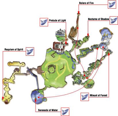
This is a map of the playable area in Ocarina of Time.
Note: ZeldaGamer21 was the person that found this map. I "stole" it from his Hyrule thread.
This is a map of the playable area in The Minish Cap.
Note: This is the first appearance of New Hyrule after the Great Flood.
This is the only map of Hyrule from Four Swords that I could find. It was merely meant as a level selection screen, so it really holds no meaning.
Note: Again, ZeldaGamer21 was the one who found this map, and I took it straight from his thread.
This is an artist's rendition of Hyrule from Four Swords Adventures.
Note: Features on this map are highly exaggerated. Since when is a castle half the size of a mountain?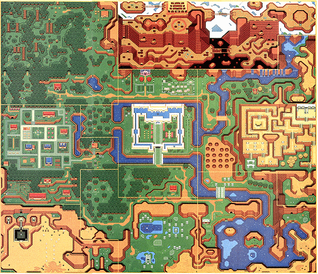
This is a map of the playable area in A Link to the Past.
Note: Things in this game are more realistically proportioned than those in FSA.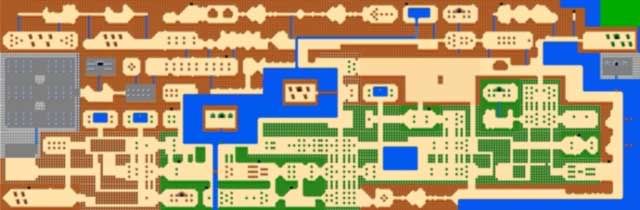
This is a map of the playable area in The Legend of Zelda.
Note: That top right screen is never seen in the game, so they made it green, although it's obvious that it's water.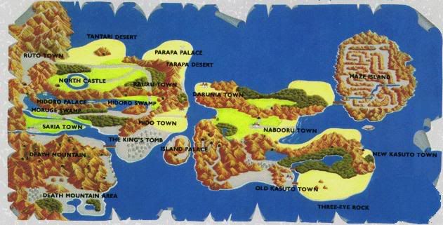
This is an artist's rendering of the playable area seen in Zelda II: The Adventure of Link.
Note: This map I didn't steal from ZeldaGamer21, despite its use on his thread. However, he did point out that the southwest corner of the map is Hyrule from LoZ.
Okay, now that you've had a chance to look over those maps a bit, I'll get started. My first comparison will be between Hyrule in OoT and ALttP. So, right now, look back at those maps and look for anything that appears in both maps in about the same place.
Ocarina of Time and A Link to the Past
What you should notice in both maps is that there's a desert in the southwest, a lake to the south/southeast, mountains to the north, and a water source in the northeast. By rotating the OoT map slightly, you can make everything match up almost perfectly. This is what people who support the ocean draining do when they compare these two maps. However, they always run into problems with the Kokiri Forest and Lost Woods and how they suddenly "migrate." Well, I have an answer to this.
Recall the rate at which the water was coming down on Hyrule at the end of TWW. That water's definately coming down fast enough to cause rapid erosion (this is also used as a mining technique, known as water blasting, if I rememer correctly), damage to buildings and other structures, and the uprooting of trees. There is no doubt that these things did indeed happen with that much water coming down, so it's rather likely that the Lost Woods were completely destroyed by the sudden rush of water. If you're a supporter of the ocean draining and revealing the "ocean floor" which was Old Hyrule, then there's no longer forests where they used to be. Over the following years, new forests would have grown across New Hyrule that would end up being cut down for housing and farmable land.
For people that support the concept of a new land being found and called Hyrule, they pretty much say that the similarities between the two lands are just coincidential. I am not trying to insult them or anything, as I supported this idea not too long ago. That is, until I started to look at things from another perspective, and now I am undecided on the matter. Have fun debating it in another thread.
Ocarina of Time and The Minish Cap
Now, some people like to place TMC before OoT, and I am strongly against that. I am not comparing their maps in order to prove or disprove this. I am instead showing how the geography of Hyrule has changed during the flood. This is for the people who say that the ocean drained and the people came down from the mountaintops of Hyrule to settle the land below. If you try to use this to justify TMC coming before OoT, then you're in for a bit of a shock. The only thing that I can possibly think of that would explain the changes in Hyrule's geography seen after the ocean drains is the flood itself. When the water came down on Hyrule to wash it away, much of the land was changed by the massive force of the water. This would end up carving basins for rivers to flow through after the ocean recedes.
Now let's look at similarities between the maps of OoT and TMC, taking into consideration the fact that the structures of Old Hyrule would have been worn away by the force of the water coming down on Hyrule. We see that there's a forest in the southeast area of Hyrule, there's a large reservoir of water to the north of that, there's mountains to the north of that body of water, and there's a massive field in the center of Hyrule.
If you were to look at the in-game map of Hyrule in OoT, you would see that there is evidence of mountains surrounding Hyrule. One such mountain could have been Mount Crenel, which would fit in nicely with the northwest corner of OoT's Hyrule Field.
Next, let's look at the southwest corner of Hyrule. In OoT's map, you see that there's a desert there. However, in TMC's map, there's a swamp. When Hyrule was flooded, the water would have sunken down into the sand and made it very unstable, much like most of Castor Wilds. However, due to a need for arable land, this area was drained. After excessive farming, the area began to suffer and became a desert. This is much like what's happening in Africa, which has actually resulted in the deserts expanding and covering more and more land.
However, there is still a problem. In FSA, there isn't a massive mountain in the southwest corner of Hyrule. Instead, there is a massive forest and a small village located inside it. I really have no explanation as to what happens to Mount Crenel, so if you've got any ideas, feel free to share them.
The Minish Cap and Four Swords Adventures
This section is for people who support the idea that a new land is found and named Hyrule after TWW. Remember, I don't want people bashing each other for what concept they choose to support, because both work just as well.
Now, comparing the two maps of TMC and FSA is rather difficult. This is because we cannot achieve a good frame of reference to overlay the maps at. There are two actual points of reference which can be used, but both have their faults. I will go over both of them, however.
If you want to use Hyrule Castle Town from TMC and Hyrule Castle from FSA as a point of reference due to them both being in the center of Hyrule, then you will notice that several key locations match up. Lake Hylia will be to the east and slightly to the north of Hyrule Castle, there will be a forested area just south of that, there will be a mountain in immediately to the north of Lake Hylia, and there will be plenty of fields to the south of the castle. Also, if you want to use the desertification method used in the concept of the ocean draining, then it will also apply here. Due to excessive farming, Castor Wilds becomes a barren land in which very few plants can grow.
However, by doing this, there are a few flaws. First, there will be another castle to the north of what is known as Hyrule Castle that should actually be inside Death Mountain. Second, and possibly most noticeable, is the fact that there's a mountain in TMC where the Lost Woods and Kakariko Village should be in FSA. I really have no way of explaining how the mountain disappears, so go ahead and give me any ideas you have.
The other frame of reference that we can use is Hyrule Castle from both maps. By overlaying them, we have several similar locations, but nothing matches up quite as well as the other placement. Noticeable similarities are a square structure to the south of Hyrule Castle (Hyrule Town in TMC, Ice Palace in FSA), the fields extend to their boundaries in FSA, and Lon Lon Ranch is in about the same place. Castor Wilds is located in about the same place as the Desert of Doubt again, so the change can still be explained by desertification. However, using this frame of reference results in even more problems than the first.
These problems are the placement of Lake Hylia in the location of the Eastern Palace, mountains being immediately to the east of Hyrule Castle, and Mount Crenel again being where the Lost Woods and Kakariko Village should be (although now further south). I prefer to use the first frame of reference, but you can choose the one you wish to use.
Four Swords and Four Swords Adventures
Four Swords has a very vague map of Hyrule. It shows only what's required for the game, and that's it. That's why I see it as being very flexible, and you will see how flexible I make it.
If you look at the map of Hyrule in Four Swords, you will see that Death Mountain is to the northwest, there is a forest to the southeast, and that there are caves to the southwest. From the look of the map, I'd say that those are plains in the northeast. Now, this doesn't match up with the map of Hyrule in FSA, now does it? Well, since Four Swords doesn't have a compass rose on the map nor any in-game text that gives the direction to another area, then we can rotate it around however we please and it can still be considered correct. So, I will now show you a rotated map of Hyrule from Four Swords.
Now that the map has been flipped, Death Mountain is in the southeast and there are plains in the southwest. If you then use Death Mountain as your point of reference and overlay the flipped Four Swords map and the Four Swords Adventures map, you will see the area behind Death Mountain. In fact, there's also a river flowing along the base of Death Mountain in the flipped FS map that can bee seen in the FSA map. This method also works because things from the FS map fit rather well with things in the AoL map.
Four Swords Adventures and A Link to the Past
I don't really have to do much explaining here. Just looking at the maps shows that almost everything matches up perfectly. There's also identical structures placed across all of Hyrule. These structures are the Eastern Palace, Desert Temple, the Mountain Tower, and Hyrule Castle. Also, Kakariko Village is in just about the same place. Both are surrounded by forested areas, so that's good enough to say that they're identical.
Comparing the rivers of the two maps shows that they also match up well. Both sets of rivers start in the northeast in a massive reservoir, flow down several waterfalls to about the same elevation as the rest of Hyrule, and flow to the sout. On their way south, they encircle Hyrule Castle, and then head southeast. The moat surrounding Hyrule Castle likely had large amounts of rock and dirt dumped into it in order to provide more methods of accessing the castle, and likely have some sort of opening underwater to allow the river to flow through.
Now, there is a major difference between the two maps in terms of geography. In the southeast of Hyrule in FSA, there is a large clearing in the surrounding forest with a small village. However, when you look in the same place on ALttP's map, you'll see a large lake there. Comparing the lake to the clearing in the trees, you can see that they're about the same shape. Based on how we humans shape the land of our planet in order to benefit ourselves, I suggest that the inhabitants of Hyrule did a similar thing. They dug out the area that the town was in and then redirected the river to the massive pit in order to fill it with fresh water for the people of Hyrule. This way, during times of drought, the people of Hyrule would have a reliable source of water for drinking and agriculture.
A Link to the Past and The Legend of Zelda
Whether or not it may look like it at first glance, these maps do have several similarities. The first and probably most important (for myself, at least) is Spectacle Rock. In ALttP, it is located high up on Death Mountain and is shaped like a pair of spectacles, or glasses. In LoZ, it is also located up in the Death Mountain area and is shaped similar to its counterpart in ALttP. The main difference, though, is that the two "lenses" are not joined. This could be the result of wind erosion up on the mountain, as mountains are incredibly windy during the summer.
Another similarity is that Death Mountain is to the north, like in all Zelda games. However, it extends farther west in LoZ than it does in ALttP. However, Death Mountain is an active volcano, so it could have had a series of massive eruptions which ended up covering the Lost Woods.
Let's look at the waterways seen in the two maps now. You can see that there's a small reservoir of water up in the mountains on both maps. By the time of LoZ, the reservoir which used to be Zora's Fountain is starting to empty. This is occuring for an unknown reason, but if I had to give one, I'd say that it's because there was once several glaciers that would provide water to the area by slowly melting.
If you then look at the flow of the rivers in both maps, you will see that they follow a similar path until they reach central Hyrule, where there are some major differences. Where Hyrule Castle once was in ALttP, there is now a massive lake with two small islands in it. If you look at the islands in LoZ's map and then look at the same area in ALttP, you will see that the eastern one is located about where the eastern tree is located in Hyrule Castle's courtyard and that the western island is located about where the smithy is. These actually work very well when compared to the islands, because they have similar things on them. The eastern island has a few small trees on it near a larger tree, and the western island has a single structure on it with a few small trees. Surely when Ganon kidnapped Zelda, he would have had to attack the castle. Knowing Ganon, he would have completely decimated the castle, so it's entirely possible that this resulted in the castle being gone. Of course, this also could have occured by natural means. The river flowing around the castle would slowly erode the rock and soil around the castle, so it'd only be a matter of time before it all started to fall apart. The area around the smithy could also have been eroded by the river flowing around the castle, or could have also suffered from Ganon's attack.
Next, we look at Lake Hylia in ALttP and the similar area in LoZ. In ALttP, Lake Hylia is a massive reservoir of water in the southeast corner of Hyrule. If the "eyeglass lake" in LoZ is to be the area surrounding Hyrule Castle and the smithy, then the large pond to the southeast of the "eyeglass lake" should be where Lake Hylia is. But what? It's so small! How did it get so small? Simple. If the reservoir that was Zora's Fountain is beginning to run empty, then Lake Hylia and the other rivers will surely suffer. This is easily noticeable in LoZ by the fact that rivers are very thin. However, look at the area south of LoZ's "source of the flow." It bears a similar shape to the corresponding area in ALttP. Because less water is now flowing from Zora's Fountain, it is not entirely filling the river it used to flow in, so we now have a partially dry riverbed. But if there's less water flowing from the source, why is there a massive lake around where Hyrule Castle used to be? This is easy to explain. By either natural (landslide) or unnatural (Ganon damming the river) means, the river to Lake Hylia has been blocked, thus stopping the flow of water to Lake Hylia. Because there is great evidence of a drought in Hyrule during LoZ, it is possible that the water in Lake Hylia has evaporated. This would cause the lake to slowly shrink until all that's left of it is a relatively large pond.
The next thing that I'd like to look at is Kakariko Village. In ALttP, Kakariko Village is located to the west of Hyrule Castle. If we then look in the same place in LoZ, however, we will see a graveyard. A very large graveyard. From the prologue of LoZ's manual, we read that Hyrule has been in chaos ever since Ganon got the Triforce of Power. Ganon may have attacked and destroyed Kakariko Village shortly after obtaining the Triforce of Power, and the remaining inhabitants most likely buried the deceased before fleeing from that area of Hyrule. This is entirely possible, because Ganon will probably now be doing whatever he can to ensure he becomes the ruler of Hyrule because he's been defeated so many times. Also, based on what we see in other Zelda games, the Hylians greatly honor the dead. To deny them of a proper burial would go against go against their traditions, so they ensured that the spirits of their dead could rest in peace.
Conclusions and Ending Statements
This thing took me hours to make, so don't you go skipping over parts of it. As you can see, the geography of Hyrule throughout my timeline flows very well with only one major problem (Mount Crenel). I hope you all find my explanations to be plausible, possible, and logical. Remember the rules I posted [hours ago] at the top of this thread when you're discussing.


